

Everything You Need to Know Before You Go to Mount Mansfield

Mount Mansfield is located in Underhill, Vermont, which is about an hour and a half east of Burlington, VT. It’s also the highest peak in Vermont within the Green mountains. Mount Mansfield is located in its own state park, which holds a lot of hiking and skiing trails. However, the road leading to Mount Mansfield is closed in the winter from mid October until late May.
If you’ve hiked any of the high peaks in New York, this mountain will feel right at home for you. It’s not as tough as a lot of the high peaks, but just as beautiful! This mountain stands at 4,393ft, has an elevation gain of 2,536ft (depending on what trail you follow), and a total distance of 7.1 miles (again, depending on what trail you follow). This is an awesome hike with SPECTACULAR views. If you want to make a weekend out of this, you could stay in Burlington, (here are some great places to stay), and do some other nearby hikes (here are some other great trails).
In this article you will read about Mount Mansfield hike, Mount Mansfield state park hours, Mount Mansfield hike difficulty, Mount Mansfield height, Mount Mansfield hike length, Mount Mansfield hike parking, Mount Mansfield hike elevation, Mount Mansfield hike Vermont, Mount Mansfield skiing, other hiking and nearby skiing, and more.
This post is all about Mount Mansfield.
Mount Mansfield:
Mount Mansfield Hike Directions
To get to Mount Mansfield State Park, you will get on Interstate 87 North (coming from Albany, get on Interstate 87 South if coming from Lake George or farther north), and take Exit 20, towards Lake George and Fort Ann. You will take a left at the light, onto US-9, towards Lake George. In half a mile you will take a right onto NY-149. Then in 12 miles you will take a left onto George Street. In 11 miles you will take a slight right turn onto Poultney Street. Then in about 7.9 miles, you will take exit 2 onto Historic Route 22A, towards Vergennes.
You will stay on this route for 42 miles, then take a left onto Ethan Alley Highway. You will stay here for 19 miles then take a slight right onto I-89 East towards I-89 and the Airport. In 1.3 miles keep right to merge onto I-89 South towards Williston and Montpelier. Then, you will take Exit 11 (in 9 miles), onto US-2 towards VT-117. Make a quick left (in 900ft) onto West Main Street towards VT-117. Then take a slight right in .2 of a mile, continuing onto VT-117. Then another quick right (250ft) onto Governor Peck Highway.
Mount Mansfield Hike Directions Continued
In about 2.3 miles you will turn left onto Brown Trace Road, and stay on this road for 5.3 miles. Then turn right onto VT-15, then take another right in .5 of a mile, onto River Road. Then another right in 3.7 miles onto Mountain Road. You will stay on Mountain Road for 2.7 miles, then drive into the parking area. This is a dirt road, but manageable for all cars. Here is a link to the GPS (Google Maps) directions. Also, this road closes from mid October (October 15th) to early April/May, for maintenance. Thus, if you want to hike this mountain, you’ll have to complete it in the summer or early fall.


{Related Post : Killington Peak & Pico Peak}
Here, is a link to some good hiking shoes, seriously, your sneakers will NOT get the traction that your hiking shoes will provide you. And always, bring PLENTY of water and snacks!
Mount Mansfield State Park Hours
Okay, once you are parked, you will go to the ticket/information office and pay, $4 per person for parking. They will give you a parking slip to put on your dashboard or mirror. There are a couple different sections to this parking area, but to get to the Sunset Ridge Trail (what I hiked, most common trail), you will go to the upper parking area. There, you will find a sign for the Sunset Ridge Trail, which is what you want. However, if you want to hike Mount Mansfield via the Hellbrook Trail, you will park in a different area (here is information and directions to this trail). To hike it via the Chin (Sunset Ridge) or the Laura Cowles trail, you will start off the same way.
Mount Mansfield Hike Continued
You will continue walking between different wooded trails and roads for about half a mile, then come upon another sign. This sign again, will inform you, that to your left, in about .2 of a mile, you will be on the Sunset Ridge trail and or, a little further down, the Laura Cowles trail. In about another .5 of a mile, you will come to a spilt for the Laurel Cowles trail, you can take this trail or the Chin (Sunset Ridge) trail to continue. Both will take you to the top. The Chin/Sunset Ridge trail will take you along the rock summit for a mile, while the Laura Cowles trail, goes through a river bed.
Trail Conditions
This trail is almost always muddy, wet, and slippery, which is why I suggest hiking it via the Chin/Sunset Ridge way. The Hellbrook way is the most difficult, it’s the shortest, but the steepest. It is a total of 3.7 miles, instead of 7.1, and it is less crowded, but it is much harder to navigate and climb. It is also typically muddy and wet, in addition, to having many large boulders and rock scrambles to climb up.
Continuing Onto Sunset Ridge Trail
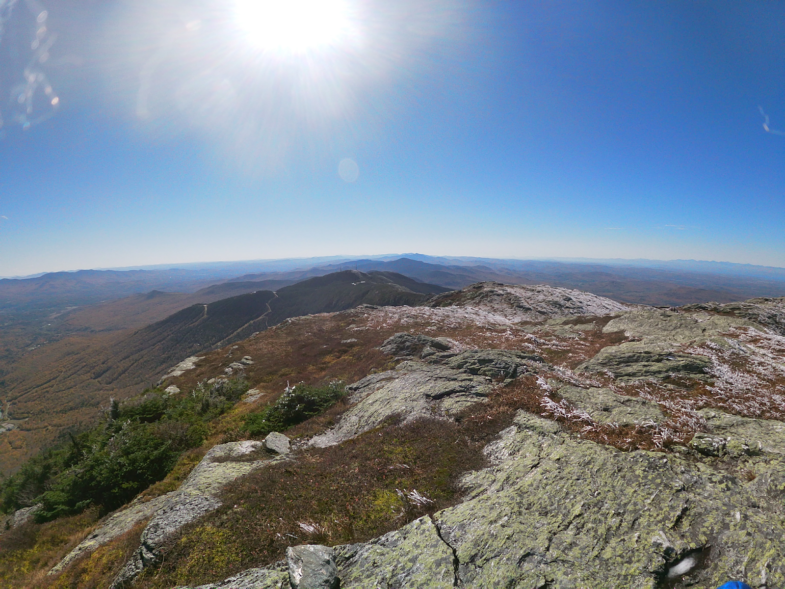
Okay, if you are continuing on the Sunset Ridge Trail (or the Chin trail), you will continue to your right, instead of going on the Laura Cowles trail. In about a mile, you will come upon an opening and start your ascent to the summit, for another mile. This last mile, is on an all rock top, thus, if you get vertigo easily, I would not recommend hiking this trail. Also, my dad and I hiked this trail, on October 9th, and there was a lot of frost and ICE on the trail. There was A LOT of ice on the rock top. It was manageable, but definitely had A LOT of dicey parts. I would bring micro spikes just in case.
If you don’t have micro spikes, then, I recommend hiking this trail in the summer or latest, end of September. If you have micro spikes, you’ll be fine (here is a link to some micro spikes). And because of the ice, and wind on top, it is VERY cold on the summit. Even if you hike this trail in the summer, I would bring at least a wind breaker (a puffy or sweatshirt, in the fall), because the higher elevated summits, are always, at least, 10-20 degrees cooler, than the bases. And put sweating into the mix, you’re going to be cold up top. Also, DO NOT hike this in your sneakers, some trails you can get away with sneakers, but NOT this one.


{Related Post : Where to Find the Best Hiking in the Green Mountains}
Mount Mansfield Summit
Okay, so once you’re at the top, it is BEAUTIFUL! Seriously, the whole last part of the hike on the rock top, is SUPER fun and cool! You get AMAZING views the whole last mile of your hike, it is SO breathtaking! Also, once you get to the rock top, there are many times that you’ll think you’re at the top, but you’re really not. This is a pretty popular trail, so as along as you keep following the people ahead of you, you’ll get to the right summit. There are also blue markers on the rocks, you can follow, as well as, a rope along the rocks, directing you where to walk. Really, you can’t miss the summit.
Now to get down, you will follow the same trail down, as you did up. Going up, this trail, took my dad and I about 2.5 to 3 hours to complete, and then only 1-1.5 to hike down. Overall, this is truly an AWESOME hike, if you enjoy rock tops, and mountains for days, you will NOT be disappointed with this hike, seriously, you’ll love it.


{Related Post : Camel’s Hump & Mount Abraham}
Mount Mansfield Skiing
Okay, don’t forget that during the winter, there is SKIING or snowboarding at Mount Mansfield in addition to hiking. The most popular public place to ski near Mount Mansfield is Stowe Mountain Resort. While Mount Mansfield is connected to Stowe, it is not a part of Stowe Mountain Resort. However, you can still see Mount Mansfield and Spruce Mountain from Stowe.
More close by ski mountains are Smuggler’s Notch (about 30 minutes away) and Bolton Valley Resort (about 50 minutes away). About an hour and fifteen minutes away are Sugarbush Ski Resort (Lincoln peak for hiking) and Stratton Ski Resort (Equinox Mountain for hiking).
Mount Mansfield Backcountry Skiing
Now, even though Mount Mansfield is not a part of any specific ski resorts, it does have amazing backcountry skiing/snowboarding. If you read this article and scroll about half way down the section : Where to Go, it will start listing different trails to use. In addition, this website will give you updates on current conditions and snow reports.

Mount Mansfield Maple Products
Lastly, I know for a lot of people, the main reason why they come to Vermont, is for the maple syrup and other maple products. Which you will find plenty of in any local grocery/general store or a maple shack in someone’s backyard, you will find maple products almost everywhere in Vermont. Specifically, Mount Mansfield Maple Products has a physical store in Winooski, Vermont (450 Weaver Street, Winnooski, VT 05404). Also, they have an online shop that you can buy products from here. Stowe Mountain Resort also has great maple products. Their physical store location is 2618 Waterbury Road, Stowe, VT 05672, also, here is a link to their online website.


And that wraps up our post about Mount Mansfield. Thank you so much for reading and I hope this article was helpful and answered any questions you had about Mount Mansfield. I hope you go check out this awesome mountain!

